

Mount Sodom Hiking Guide
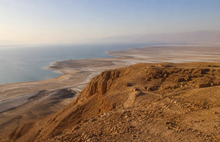
Mount Sodom is a dramatic, towering salt mountain located at the southwestern edge of the Dead Sea in southern Israel. Known for its striking desert landscapes, incredibly unique geological formations, and the famous Lot’s Wife salt pillar, it offers one of Israel’s most unforgettable outdoor experiences. Combining panoramic views of the lowest place on earth with fascinating rock layers and rugged desert terrain, Mount Sodom hiking delivers an adventure completely unlike anywhere else in the country. Whether you are an avid hiker looking to conquer desert ladders or a traveler eager to explore biblical history, this comprehensive guide covers everything you need to know to plan your trek.
Where Is Mount Sodom?
Located in the rugged Judean Desert, the mountain sits directly along the southwestern shores of the Dead Sea. It runs parallel to the famous Route 90, making it highly accessible for travelers exploring the southern region of Israel. The mountain stretches for about 11 kilometers (7 miles) long but is relatively narrow, creating a distinct, sheer wall of rock and salt that borders the highway.
If you are mapping out your itinerary, the site is situated just south of the hotel district of Ein Bokek and very close to the small settlement of Neve Zohar.
Driving Directions:
- From Jerusalem: The drive takes approximately 1.5 to 2 hours. You will take Route 1 east through the Judean Desert, descending toward the Dead Sea, and then head south on Route 90 past Ein Gedi and Masada.
- From Ein Bokek: It is a very short, 10-to-15-minute drive south along Route 90.
- From Tel Aviv: The drive takes roughly 2.5 hours, usually routed through the city of Arad (Route 31) before dropping down to the Dead Sea basin and connecting to Route 90.
(Tip for travelers: We highly recommend embedding a Google Maps pin of the “Fish Trailhead” or “Lot’s Wife Pillar” into your offline maps before losing cell service in the desert!)
Why Is Mount Sodom So Unique?
To truly appreciate the landscape, you have to understand what you are walking on. This is not a standard rock mountain; it is one of the world’s largest natural salt diapirs. Millions of years ago, the area was flooded by the Mediterranean Sea. When the waters eventually retreated and evaporated, they left behind massive layers of salt.
Over countless millennia, geological pressure from the tectonic plates of the Syrian-African Rift squeezed this subterranean salt upward much like squeezing a tube of toothpaste. This continuous upward movement formed the mountain we see today, which is still rising at a rate of a few millimeters per year.
Fascinating Geological Facts:
- It is almost entirely salt: The mountain is composed of roughly 80% halite (pure rock salt). It is capped by a thin, protective layer of limestone, clay, and conglomerate rock that prevents the entire mountain from dissolving away in the rain.
- Constantly changing: During the rare winter flash floods, water seeps through the cracks in the limestone cap, violently dissolving the salt beneath. This creates an incredible, ever-changing labyrinth of underground salt caves, deep sinkholes, and vertical drainage shafts.
Mount Sodom Hiking Routes
When it comes to hitting the trail, there are a few distinct ways to experience the area. The trails here range from quick roadside stops to challenging desert treks.
The Fish Trail (Shvil HaDagim)
This is the premier route and the centerpiece of any Mount Sodom hiking itinerary. Named for the fossilized fish skeletons occasionally found in the ancient rock layers, this moderate-to-challenging loop offers the best overall experience of the mountain.
- Length: Approximately 5 to 7.5 kilometers (depending on your exact parking spot and return route).
- Estimated Time: 3 to 4 hours.
- Elevation Gain: Roughly 200 meters. You are starting below sea level, so the “peak” is still lower than the Mediterranean Sea!
- The Route: The trail typically begins with a steep, demanding ascent up the side of the mountain. Once you reach the flat summit ridge, the hike transforms into a spectacular ridge walk. The descent is the most famous part: you will navigate down deep, narrow chalk and salt crevices using a series of built-in metal ladders and rungs secured into the rock face.
- Highlights: Incredible panoramic viewpoints of the Dead Sea, close-up looks at the bizarre geological layers, and a thrilling, hands-on descent.
The Lot’s Wife Route
If you are looking for a shorter, highly accessible option without the physical demands of the Fish Trail, exploring the base of the mountain near the Lot’s Wife formation is ideal.
- The Experience: Located right off Route 90, this towering, humanoid-shaped pillar of salt has detached from the main cliff face. It is a fantastic spot for photography and requires almost no hiking.
- Connectivity: Several longer trails begin or end near this iconic formation. You can easily park, admire the site, and take a short, flat walk along the base of the mountain to observe the massive salt blocks up close.
Wadi Pratzim & The Flour Cave
While technically located just to the west of the salt mountain, this route is frequently combined with a visit to the area.
- The Experience: This is an easy, mostly flat hike through a winding, brilliantly white chalk canyon. The chalk is so fine that touching the walls leaves a white, flour-like dust on your hands hence the name.
- The Flour Cave: The trail traditionally leads through a dark, narrow cave. Important Note: Visitors must always verify current safety advisories with the Nature and Parks Authority, as the Flour Cave is occasionally closed due to the risk of rockfalls.
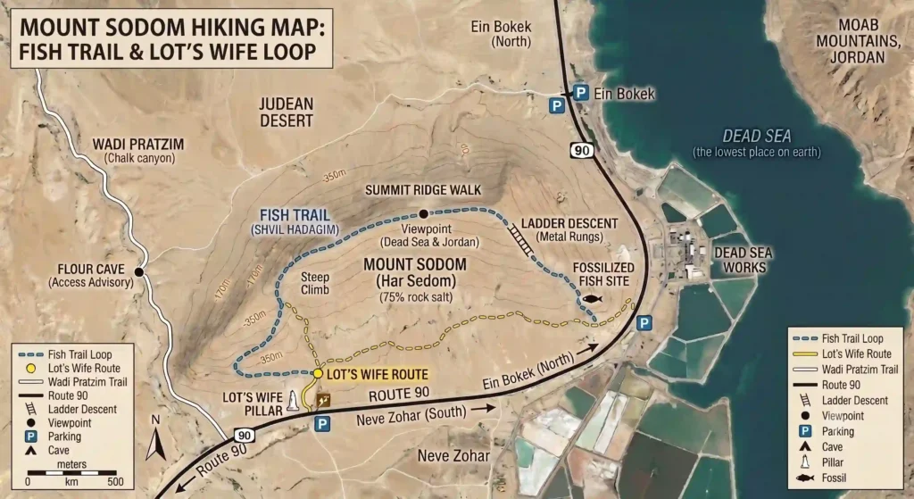
Mount Sodom Hiking Map & Trail Overview
Before stepping out of your vehicle, it helps to visualize the route. Most hikers tackle the Fish Trail as a loop.
- Trailhead & Parking: You will typically park your car in the designated dirt lots right off Route 90, near the Dead Sea Works or the Lot’s Wife pillar.
- The Ascent: Look for the marked trail (usually blue or green trail blazes) that begins winding sharply up the eastern face of the mountain. Take your time here; the desert sun is unforgiving, and the screen can be loose.
- The Summit Ridge: Once at the top, the trail flattens out. You will walk along the plateau, following the trail markers. This is where you want your camera out.
- The Ladder Descent: The trail eventually cuts into a narrow gorge. Here, you will stow your walking poles and use your hands and feet to descend a series of secured metal ladders.
- The Return: After reaching the bottom of the canyon, the trail spills out onto the desert floor, leaving you with a flat walk back to your vehicle.
(We highly recommend downloading an official trail map from the Israel Nature and Parks Authority or using an offline GPS hiking app like Israel Hiking Map before you arrive.)
What Will You See During the Hike?
The visual rewards of this trek are immense. As you ascend the ridge, you will be treated to sweeping, unobstructed views of the vibrant blue waters of the southern Dead Sea. The contrast between the stark white salt, the brown desert crust, and the turquoise water is mesmerizing.
Look across the water, and you will see the towering red and purple peaks of the Moab Mountains in neighboring Jordan. Beneath your feet, keep an eye out for the distinct, wavy bands of sediment and salt a visual record of millions of years of geological history. If you are very observant, you might spot the tiny, delicate impressions of fossilized fish embedded in the lighter chalk layers. As you descend, the towering, narrow walls of the desert canyons will make you feel incredibly small against the vastness of the Judean Desert.
Is Mount Sodom Hiking Difficult?
Honesty is crucial when discussing desert trails. Mount Sodom hiking is generally rated as moderate to challenging.
This is not a casual, paved nature walk. The terrain is rocky, uneven, and often slippery due to loose gravel and salt dust. The ascent requires a good level of cardiovascular fitness. Furthermore, the descent via the metal ladders requires mobility, balance, and a lack of severe vertigo. You must be comfortable using your hands to climb down backwards.
Who is this hike for? It is perfect for fit adults, teenagers, and adventurous older children who have hiking experience. It is not suitable for toddlers, individuals with knee or mobility issues, or anyone terrified of heights.
Best Time to Hike Mount Sodom
Timing is everything in the Judean Desert.
The Best Season: The only safe time to hike here is from mid-January through May. The weather is crisp, sunny, and perfect for physical exertion.
When to Avoid: Do not attempt to hike this mountain during the late spring, summer, or early autumn. Temperatures in the Dead Sea basin regularly exceed 40°C (104°F) during these months. The mountain offers absolutely zero shade, and the white rock reflects the sun intensely. Hiking here in the summer is extremely dangerous and invites severe heat exhaustion.
Regardless of the season, early morning hikes are strongly recommended to beat the midday sun and enjoy the spectacular light of the desert sunrise.
Practical Visitor Information
Before you hit the road, keep these quick logistics in mind:
- Parking: Free dirt parking is available along Route 90 near the major trailheads. Do not leave valuables visible in your car.
- Trail Markings: Trails are marked with color-coded stripes painted on rocks.
- Cell Reception: Reception is spotty at best on the mountain and often drops completely inside the canyons. Download offline maps.
- Facilities: There are no restrooms, water fountains, or kiosks on the mountain.
- Nearest Amenities: The closest gas station, restaurants, and proper restrooms are a short drive north in the Ein Bokek hotel area, or just south at the Neve Zohar junction.
- Dogs: While dogs are generally allowed in open desert areas, the metal ladders and sharp salt rock on the Fish Trail make it highly unsuitable and dangerous for pets.
Safety Tips
Because Mount Sodom is made of unstable salt rock and sits in a harsh desert environment, strict adherence to safety rules is non-negotiable:
- Stay strictly on marked trails: The mountain is riddled with deep, hidden crevices and open vertical shafts created by dissolved salt. Wandering off the path can result in a fatal fall.
- Never enter closed caves: Unless you are with a certified rappelling guide on an approved route, do not enter the salt caves. They are prone to sudden collapses.
- Carry 3-4 liters of water: Per person. Do not underestimate how quickly the dry desert air dehydrates you.
- Wear closed-toe hiking shoes: The rock is sharp, and flip-flops or sandals are completely inappropriate for the ladders and scree.
- Pack sun protection: A wide-brimmed hat, sunglasses, and high-SPF sunscreen are mandatory.
- Check the weather: Flash floods in the Judean Desert are deadly. Never hike in the region if there is a forecast for rain anywhere in the eastern mountains or Jerusalem area.
Explore Mount Sodom with a Private Guide
- Navigating desert logistics, reading trail maps, and understanding the complex layers of geology and history can be overwhelming. Many visitors prefer exploring the region with a knowledgeable private guide instead of navigating the desert trails on their own.
- Booking a private tour provides immense benefits: you get seamless, air-conditioned transportation, expert route planning tailored to your fitness level, and the absolute highest standards of safety. More importantly, an expert guide transforms the hike. They will provide the vital biblical context, point out hidden fossils you would otherwise miss, and explain the incredible geological forces beneath your feet.
- At Dekel Tours, we specialize in crafting the perfect custom private tours, ensuring you get to visit Masada, float in the sea, and hike the desert all at a comfortable, luxurious pace.
Nearby Attractions
To make the most of your trip south, consider combining your hike with other incredible regional highlights:
- Masada National Park: Explore King Herod’s ancient desert fortress.
- The Dead Sea: Float in the hypersaline waters and cover yourself in mineral-rich mud at the public beaches of Ein Bokek. Ein Gedi: Hike through lush desert oases and waterfalls.
- Neve Zohar: Enjoy a quiet evening near the southern basin.
Conclusion
Mount Sodom is more than just a challenging desert trek; it is a journey through millions of years of geological history and thousands of years of biblical tradition. From the sparkling views of the Dead Sea to the thrill of descending through fossil-lined canyons, this landscape leaves a lasting impression on everyone who visits. Whether you are embarking on your first Mount Sodom hiking adventure or returning to explore the mesmerizing salt caves, proper preparation and a spirit of adventure will guarantee an incredible experience. If you want to maximize your time and gain deeper insights, consider reaching out to arrange a guided private tour to bring the magic of the Judean Desert to life.
It is located in the southern Judean Desert in Israel, running directly along the southwestern shore of the Dead Sea. It sits adjacent to Highway 90, just south of the Ein Bokek hotel district and near the small community of Neve Zohar.
Yes, the primary routes (like the Fish Trail) are considered moderate to challenging. The hike involves a steep, strenuous ascent over loose gravel, walking along an exposed ridge, and descending through narrow canyons using metal ladders bolted into the rock. It requires a good baseline of fitness and mobility.
If you are hiking the popular Fish Trail (Shvil HaDagim) loop, you should expect the journey to take between 3 and 4 hours, depending on your pace, how often you stop for photos, and the size of your group navigating the ladders.
Survival in the desert requires preparation. You must bring at least 3 to 4 liters of water per person. Wear sturdy, closed-toe hiking shoes with good grip. Pack a wide-brimmed hat, sunglasses, high-SPF sunscreen, and high-energy snacks. Finally, ensure your phone is fully charged and loaded with an offline trail map.
Yes! The famous Lot’s Wife salt pillar is located right at the base of the mountain along Route 90. It is highly accessible and requires almost no hiking to view. Many hikers choose to stop and photograph the pillar either right before they begin their main hike or immediately after finishing.